After much searching, bare land not being easy to find, we discovered the perfect location. Low down on Eagle Ridge Road was a property with fantastic views nice and close in to town. They problem was - it was in Boulder County. We didn’t know it at the time, but Boulder county had one of the first urban growth boundaries in the United States. It was called The Boulder Blue Line. Here’s a bit of the origin.
“In the late 1950s Professor Robert McKelvey of Mathematics and I and others would talk occasionally about the problems that were becoming apparent as Boulder’s population was growing from the 1950 U.S. Census figure of 19,999. The earliest recollection that I associate specifically with the Blue Line was one evening about 5 PM, I was walking home from the Physics Building on the campus of the University of Colorado (In 2000 this is the old part of the Ramaley Building) and as I reached the cul-de-sac immediately north of Norlin Library, Bob came by on his bike and we stopped to talk.
He said, “Al, we have to do something about all of the houses that are being built up in the foothills.”
I can remember thinking to myself, “Bob, you’re out of your mind. What can we do? We are just a couple of nobodies and the home builders are rich and powerful, and are working closely with the City Council.” ( http://www.boulderblueline.org/?page_id=111 )”
Why did they think it was any of their business what people did with their property?
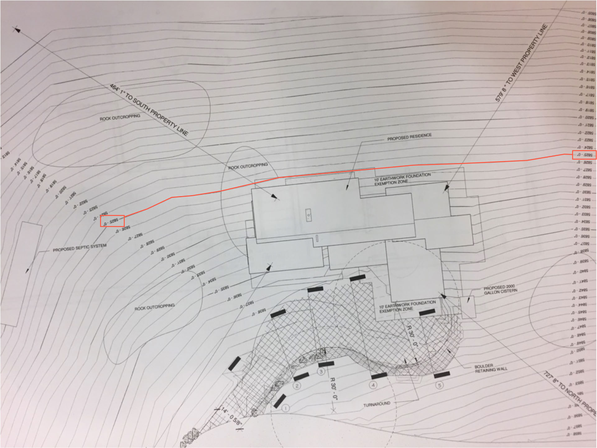
Obviously, if we’d know about that attitude, which has actually gotten worse over time, we would never even bothered with anything in Boulder County. Fortunately we had engaged a fantastic buyer’s agent, Agents for Home Buyers, who knew all about Boulder county and he put into the contract “Subject to Site Plan Approval by all parties”. Our architect submitted the following site plan.
The planners response was:
“Staff finds that an alternate location lower on the hillside, which matches the pattern of existing development on the ridge would be most appropriate. More specifically, a location at or before the steep sharp curve on the lower portion of the property. However, if the current location is still proposed, a maximum roofline elevation of 5,825 feet above sea level would be the minimum required to not break the natural ridgeline and visual landscape from surrounding areas. From the attached photos you can see that the proposed existing grade of the northwest corner of the house will be approximately the point that appears to be the ridge from several locations in Lyons and from US 36.
“Staff also indicated that, due to the highly visible nature of this lot, any house located on this property will require maximum tree preservation, reduced windows and glazing to less than 20% of the west facing façade and natural color tones to match the topography will be required as mitigation of visual impacts.”
As you can see from the county planners response, the highest roof they would allow would be at the 5825’ elevation. In the drawing above, the elevations go from lowest at the top, to highest at the bottom. I’ve highlighted the 5825’ line. It is, by amazing coincidence, exactly where the bottom of the foundation is.
The planners are telling us that the only plans they will accept for this location are BELOW GROUND. They are telling us we can’t have the glass wall that The Views needs!
And you wonder why libertarians are now the largest group in Gallup’s polling http://reason.com/blog/2016/03/08/the-libertarian-moment-is-so-over-that-l . Needless to say, we exercised the cancellation clause and all we lost was about two years time. It had taken us a year to find the Eagle Ridge Property, it would take us another 9 months to find an even better one in Larimer county.